For the first time ever, Google maps uses camel to capture the Liwa Desert terrain.
If you want a job at Google, be a camel. For the first time ever, the US-based tech giant has employed a camel to capture the landscape of the Liw Desert in Abu Dhabi, UAE. By mounting a Trekker camera on top of the camel, Google seeks to document the desert terrain in its most natural form. 10-year-old camel Raffia and her guide start their job at 6 am, when the lighting is the best.
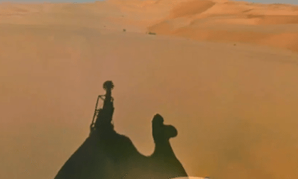
A spokesperson for Google addressed the media and said, “With every environment and every location, we try to customise the capture and how we do it for that part of the environment. In the case of Liwa we fashioned it in a way so that it goes on a camel so that it can capture imagery in the best, most authentic and least damaging way.”
The images captured by the Trekker camera show sand dunes, other camels, an oasis and some people in the desert. The Google Street View feature has been a part of Google maps from 2007 and Google is keen on improving the scope of the feature.
Usually, the street shots are captured by the Trekker camera in a car. However, there have been times when the Trekker has been attached to people (to document the Grand Canyon) and sent underwater (Venice).